![Tsunoshima Bridge 2026: 3 Views & Driving Guide [Photos]](https://hiddenjapan-gems.com/wp-content/uploads/2026/04/IMG_0545.webp)
在本州最西端,有一座橋下的海水看起來就像經過修圖一樣美得不真實。 1,780 meters of concrete curve across an expanse of turquoise and emerald that has no business existing in mainland Japan, but it does, and it is free to drive across. Tsunoshima Ohashi (角島大橋), connecting the Yamaguchi coast to the small island of Tsunoshima, is one of Japan’s most photographed drives and still remarkably uncrowded compared to the country’s big-name scenic spots. 我是 Hidden Japan Gems 的 Nobutoshi。以下是為什麼它在 2026 年值得繞道一訪。
基本資訊
| 項目 | 資訊 |
| 名稱 | Tsunoshima Ohashi Bridge (角島大橋) |
| 位置 | Hohoku-cho, Shimonoseki City, Yamaguchi Prefecture |
| 長度 | 1,780 meters (one of Japan’s longest free-access remote-island bridges) |
| 通車日期 | November 3, 2000 |
| 過路費 | 免費通行 |
| Construction Cost | Approximately ¥14.9 billion |
| 最佳觀景點 | Amigase Park (海士ヶ瀬公園) observation area |
| 最佳時間 | Late morning (10:00 AM to 12:00 PM) on a sunny day |
| From Shimonoseki | Approximately 1 hour by car |
| From Shin-Yamaguchi Station | Approximately 1 hour 20 minutes by car |
| 大眾運輸 | 可搭乘但班次稀少 — 強烈建議租車 |
| 島上設施 | Tsunoshima Lighthouse, white sand beaches, seafood restaurants |
為什麼角島大橋值得一去
Japan is full of beautiful coastlines, but emerald-colored water is mostly confined to Okinawa and a few southern islands. That is what makes Tsunoshima different. The Sea of Japan, in this specific shallow bay on the western tip of Honshu, turns a clear turquoise that rivals tropical destinations, and you can drive across it in a car.
The reasons for the extraordinary water color are straightforward. The bay between Tsunoshima and the mainland has an unusually shallow, sandy seabed with fine white sand that reflects light back through the clear water. There is limited river runoff in this stretch of coast, meaning no major rivers dump sediment into the bay, keeping visibility exceptionally high. The bridge itself curves deliberately rather than running straight, creating dramatic photographic perspectives from the viewpoint above. And unlike many of Japan’s scenic long-distance bridges that charge tolls, Tsunoshima Ohashi is completely free to cross in both directions.
Add in that the bridge connects to an island where you can actually swim, eat fresh seafood, and visit a 150-year-old lighthouse, and you have one of the best driving destinations in western Japan.
三個必看的視角
Tsunoshima Ohashi is best experienced from three distinct perspectives. Get all three, and you have seen it properly.
視角一:從空中俯瞰
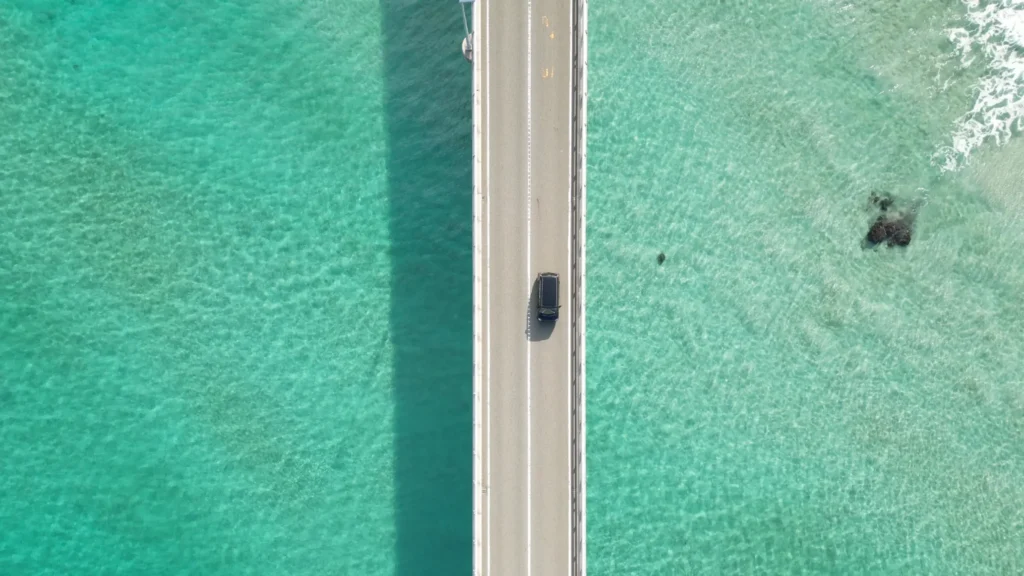
This is the shot that made Tsunoshima famous on social media. Looking straight down from above, the water is so clear you can see the seabed: rocks, sand patterns, the shadow of the bridge itself cutting a clean rectangle across the turquoise. A car crossing looks like it is driving over open water rather than a bridge.
Most visitors cannot take this exact shot themselves because it requires a drone, and drone flight near the bridge is subject to Japanese civil aviation rules. But it is the image you will see on postcards and travel brochures, and understanding that this is what the water really looks like from above reframes the whole experience. When you stand at the viewpoint below, remember: this is what is underneath you.
視角二:從側面看海岸
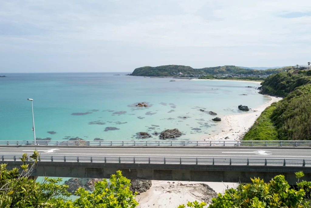
This is the view from just beside the bridge deck itself. Looking east along the coastline, you see the shallow turquoise bay with clusters of dark rocks scattered across the seabed, some exposed above the waterline, others visible through the clear surface. The road railing in the foreground grounds the shot, while the curving coastline leads your eye to the distant mainland communities.
What this view teaches you is that the water is not uniformly colored. Different depths and sand textures create bands of emerald, turquoise, and deep blue. The effect changes by the hour as the sun moves. This view is accessible from a pullover point just before the bridge begins, or by walking from the main viewpoint down toward the bridge approach.
視角三:從觀景台拍攝經典全橋照
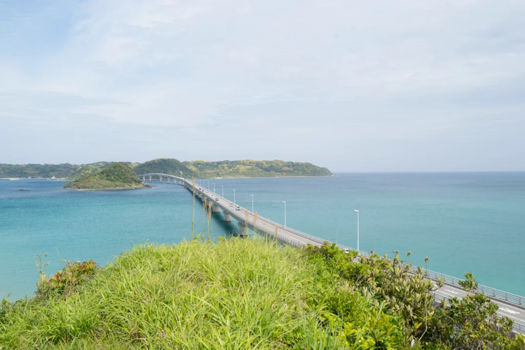
This is the shot that sells Tsunoshima to the rest of Japan. From the Amigase Park observation area (海士ヶ瀬公園展望台), you stand on an elevated bluff above the bridge approach and look across the entire 1,780-meter span. The bridge curves gently to the left, crossing bands of turquoise and deep blue, before landing on the green hills of Tsunoshima island.
On a sunny day between 10:00 AM and 2:00 PM, when the sun is high enough to light up the shallow water, the color contrast between the emerald bay and the dark green island is extraordinary. This is the photograph that convinced you to come here, and seeing it in person is a different experience from any image: the scale is larger, the colors are more layered, and the sound of the waves from below adds something no photograph can carry.
如何前往
Tsunoshima Ohashi is in the northwestern corner of Yamaguchi Prefecture, along the Sea of Japan coast. 強烈建議租車前往,因為大眾運輸班次稀少且彈性有限。
租車前往(推薦)
Driving gives you the freedom to stop at the viewpoints and explore the island at your own pace. Pick up a rental at Shimonoseki, Shin-Yamaguchi, or Fukuoka Airport. The drive itself is scenic: National Route 191 from Shimonoseki passes through small fishing villages and along cliffs overlooking the Sea of Japan. If you are unfamiliar with driving in Japan, read our guide to using Japan’s highway system with a rental car.
| 出發地 | 距離 | 時間 |
| Shimonoseki IC | Approximately 60 km | Approximately 1 hour |
| Shin-Yamaguchi Station | Approximately 100 km | Approximately 1 hour 20 min |
| Hagi | Approximately 70 km | Approximately 1 hour 15 min |
| Fukuoka (Hakata) | Approximately 150 km | Approximately 2 hours |
| Hiroshima | Approximately 260 km | Approximately 3 hours |
Looking for rental car deals in western Japan? Check availability on Klook for competitive rates at major airports and train stations.
搭乘大眾運輸(適合有耐心的旅人)
Public transport to Tsunoshima is possible but not convenient.
1.From Shimonoseki Station, take the JR Sanin Main Line to Kottoi Station (特牛駅) or Takibe Station (滝部駅). The ride takes approximately 80 minutes.
2.Transfer to the Blue Line Kotsu (ブルーライン交通) bus bound for Tsunoshima.
3.Get off at the Hotel Nishi-Nagato Resort Iriguchi (ホテル西長門リゾート入口) bus stop for the mainland viewpoints.
4.Warning: Buses run only 4 to 5 times per day, and some services do not operate on Sundays and public holidays. Missing a bus means waiting several hours.
For general tips on navigating Japan’s rail system, see our complete guide to traveling around Japan. If you are flying into the region, our Japan airport and flight guide covers the closest airports including Yamaguchi Ube and Fukuoka.
Southeast Asia Traveler Tips
If you are visiting from Singapore, Malaysia, Thailand, or Indonesia, here are a few things to keep in mind for this destination:
•Driving side: Japan drives on the left, identical to Singapore, Malaysia, and Thailand, making the transition easier for drivers from these countries.
•Summer heat: If visiting between July and September, be aware that the coastal sun is intense with very little shade at the bridge viewpoints. Bring an umbrella or hat. The summer humidity here is comparable to what you experience at home, but the UV exposure on the open coast is stronger.
•Payment: While major rental car companies accept credit cards, the lighthouse admission (¥300) and small local seafood stalls on the island often require cash only. Withdraw yen at a 7-Eleven ATM before leaving Shimonoseki.
•Flights: From Singapore, Scoot and Jetstar Asia offer direct flights to Fukuoka. From Bangkok, AirAsia Japan and Thai AirAsia X fly to Fukuoka. From there, it is a 2-hour drive to the bridge.
•Visa: Singapore, Malaysia, and Thai passport holders can enter Japan visa-free for up to 30 days (Singapore) or 15 days (Malaysia, Thailand). Indonesian passport holders need a visa in advance.
海士瀨公園觀景台
Amigase Park is the single most important stop on your visit, and 90% of visitors photograph the bridge from here. The park sits on an elevated bluff directly above the bridge approach on the mainland side.
The park has a main observation deck with the classic full-bridge view, a lower observation area closer to the bridge approach, free parking for approximately 100 cars, public restrooms, and a small rest area with vending machines. An information board explains the bridge’s construction and the surrounding marine environment. Walking between the different observation points takes 5 to 15 minutes. The main viewpoint is on a grass-covered bluff, so bring shoes you do not mind getting slightly wet if there has been recent rain.
Photography timing at Amigase Park:
•Late morning to early afternoon (10:00 AM to 2:00 PM): Best water color. The sun is high enough to light the shallow bay.
•Golden hour (sunset): Softer colors with the bridge silhouetted against a warm sky, but the emerald water effect diminishes.
•Cloudy days: The water color loses dramatically. If your visit falls on a cloudy day, consider whether to reschedule.
Parking fills on weekends and holidays around noon. Arrive earlier or later for easier parking.
Driving Across the Bridge
The drive across Tsunoshima Ohashi itself takes about 3 minutes. It is a two-lane road with a speed limit of 50 km/h. The experience is exhilarating but quick, so do not rush to the far side. Turn around on the island and come back to extend the experience.
There are no stopping points on the bridge itself. No pull-offs, no photo stops. For photos, use the viewpoints at either end. Strong winds from the Sea of Japan can make the bridge uncomfortable or temporarily closed, so check conditions before driving, especially in winter.
Bicycle crossing is allowed. Cyclists do cross the bridge, though it is exposed and sometimes windy. Walking is technically allowed on the pedestrian path, but the 1,780-meter walk is long and exposed. Most people drive.
The view while driving is striking but less photogenic than the viewpoint above because you are at water level and the turquoise effect is harder to see from inside a car. For the iconic view, stop at Amigase Park first, then drive the bridge.
What to Do on Tsunoshima Island
The bridge delivers you to Tsunoshima, a small island of about 4 km by 2 km with a resident population of around 700 people. It is worth spending 1 to 2 hours exploring.
1. Tsunoshima Lighthouse (角島灯台)
At the western tip of the island stands a 150-year-old granite lighthouse, one of Japan’s 16 “climbable lighthouses” (参観灯台) where you can climb to the top. Built on March 1, 1876 by British engineer Richard Henry Brunton, it is a stunning piece of Meiji-era architecture constructed from unpainted granite. For an admission fee of ¥300 (junior high school age and older; free for elementary and younger), you can climb the 105 narrow spiral steps to the top for a 360-degree panorama of the Sea of Japan.
2026 Update: In March 2026, 14 of Japan’s 16 climbable lighthouses introduced a lunch break closure (12:00 to 13:00). However, the Tsunoshima Lighthouse is explicitly excluded from this rule and remains open throughout the day. Hours: March to September 9:00 to 17:00, October to February 9:00 to 16:30.
2. White-Sand Beaches
The island has several small beaches with fine white sand. Sunokoshi Beach (砂駒海岸) and Shihohama Beach are popular. In summer (July to August), you can swim with lifeguards on duty. In other seasons, the beaches are nearly empty and photogenic.
3. Seafood Restaurants
Several small restaurants on the island serve fresh catches from the Sea of Japan. Squid (ika) and sea urchin (uni) are local specialties. Most are cash-only and close by early evening.
4. Tsunoshima Lighthouse Park (角島灯台公園)
The area around the lighthouse is a small park with walking paths, viewpoints over the Sea of Japan, and a small museum about the lighthouse’s history. Free parking is available here.
5. Photo Spots Across the Island
The island’s ring road offers multiple pullovers with coastal views. The northern coast faces open sea and is dramatic. The southern coast faces the bay and offers calmer views of the bridge you just crossed.
最佳造訪時間
The water color is everything at Tsunoshima, and it changes dramatically with the weather and season.
| Season | What to Expect |
| Spring (April to May) | Mild weather, green hills, good water color. Cherry blossoms bloom around the island in early April. |
| Summer (June to August) | Peak water color. The emerald and turquoise effect is strongest under bright summer sun. Swimming available. Also the most crowded time. |
| Autumn (September to October) | Still warm, clear skies, fewer crowds than summer. One of the best times to visit. |
| Winter (December to February) | Cold, often gray skies, strong winds from the Sea of Japan. Water color loses its tropical quality. Not recommended for the classic experience. |
Crowd patterns:
•Weekday mornings: Very quiet
•Weekend middays: Moderate crowds at the viewpoint; parking can fill
•Golden Week (late April to early May) and Obon (mid-August): Heaviest crowds of the year
•Off-season weekdays (October to November): Nearly empty
Combining with Other Yamaguchi Sites
Yamaguchi Prefecture has a surprisingly high concentration of photogenic spots. Combine Tsunoshima Ohashi with any of the following for a multi-day trip.
1. Motonosumi Shrine (元乃隅神社)
About 45 minutes’ drive from Tsunoshima. 123 vermilion torii gates cascade down a cliff toward the Sea of Japan. One of Japan’s most visually dramatic shrines. The drive along the Kita-Nagato Coast between Tsunoshima and Motonosumi is a highlight in itself.
2. Akiyoshidai Plateau (秋吉台)
About 1 hour 30 minutes’ drive. Japan’s largest karst plateau, a surreal terrain of limestone pillars rising from green grasslands. Below the plateau, Akiyoshido Cave is one of Japan’s largest limestone caves.
3. Hagi (萩)
About 1 hour 15 minutes’ drive. A preserved Edo-period castle town with samurai houses and pottery kilns. Birthplace of several Meiji Restoration leaders.
4. Shimonoseki and Kanmon Strait
About 1 hour back toward the south. The strait separating Honshu from Kyushu, famous for fugu (pufferfish) cuisine and the walking-accessible Kanmon Tunnel that lets you literally walk under the strait to Kyushu.
Suggested 2-Day Yamaguchi Itinerary
•Day 1: Tsunoshima Ohashi (morning) → Motonosumi Shrine (afternoon) → stay in Hagi
•Day 2: Hagi castle town (morning) → Akiyoshidai (afternoon) → return to Shin-Yamaguchi
Planning a longer trip through western Japan? Our Ruby Route 7-day Kyushu adventure easily connects to Yamaguchi via Shimonoseki, and our Beyond the Golden Route itineraries offer more off-the-beaten-path ideas.
Looking for hotels in the area? Search Shimonoseki and Hagi hotels on Agoda for the best rates near the bridge.
實用建議
•It is free. No toll, no admission, no parking fee at Amigase Park. One of the rare top-tier attractions in Japan with zero cost barriers.
•Check the weather before you go. The entire appeal is the water color, and cloudy days dramatically reduce it. A clear sunny day transforms the experience.
•Fuel up before you leave Shimonoseki. Gas stations in rural Yamaguchi are sparse. Fill up before driving to Tsunoshima.
•Respect the residents. Tsunoshima is home to approximately 700 people who deal with daily waves of tourists. Do not block residential driveways, keep voices down, and respect private property. For more on this topic, read our guide to photography etiquette in Japan.
•Use the designated viewpoints for photos. Stopping on the bridge or pulling over on the approach is dangerous and sometimes illegal.
•Bring layers even in summer. Sea breezes can be cool, and the exposed viewpoint gets windy.
•Cash for the lighthouse and small restaurants. Card acceptance on the island is limited.
•Drones: Japanese drone regulations apply. Drone flight is restricted near the bridge and requires permits in most cases. Do not assume you can fly one.
•Allow 2 to 4 hours total. A rushed visit is possible in 1 hour including the viewpoint and a drive across, but to include the lighthouse, a beach stop, and lunch, plan for 3 to 4 hours.
Strategic FAQ
How much does it cost to cross the Tsunoshima Ohashi Bridge?
Crossing the bridge is completely free in both directions. There are no tolls, no parking fees at the main Amigase Park viewpoint, and no admission to the observation areas.u003cbru003e
How do I get to Tsunoshima Ohashi from Tokyo?
Fly to Fukuoka (Hakata) or Yamaguchi Ube Airport. From Fukuoka, rent a car and drive approximately 2 hours. From Yamaguchi Ube, drive approximately 1.5 hours. By train, take the Shinkansen to Shin-Yamaguchi, then rent a car for the approximately 1 hour 20 minute drive.
Can I visit Tsunoshima without a car?
Yes, but it is difficult. Trains from Shimonoseki to Kottoi Station take approximately 80 minutes, followed by infrequent local buses that run only 4 to 5 times per day. A rental car from Shimonoseki or Shin-Yamaguchi is strongly recommended.
What makes the water at Tsunoshima look so blue and green?
A combination of shallow seabed, fine white sand, lack of major river runoff causing sediment, and the angle of sunlight penetrating the clear water. The effect is strongest on sunny days between late morning and early afternoon.
When is the best time of day to photograph Tsunoshima Ohashi?
The best time is between 10:00 AM and 2:00 PM on a sunny day. The sun needs to be high enough to light up the shallow water from above. Early morning and late afternoon light flattens the water color.
Can I swim at Tsunoshima?
Yes. Sunokoshi Beach on the island is a designated swimming beach with lifeguards in summer (July to August). Outside summer, the beaches are open but unstaffed.
Is the bridge open year-round?
Yes, the bridge is open year-round. However, it may close temporarily during severe weather such as typhoons, strong winds, or heavy snow. Check conditions before a winter visit.
How long should I spend at Tsunoshima?
Minimum 1 hour for the viewpoint and a quick drive across. Ideal is 3 to 4 hours including the lighthouse, a beach stop, and lunch on the island. Enthusiasts can easily spend a full day.
Is Tsunoshima Ohashi crowded?
Far less crowded than most of Japan’s famous scenic spots. Weekday mornings are nearly empty. Weekends and summer holidays see moderate crowds at the viewpoint, but it never feels overrun.
Can I fly a drone over the bridge?
Japanese drone regulations restrict flight near public infrastructure. Flying a drone over the bridge or road area without authorization is prohibited. The classic aerial photos you see online were taken with specific permits or from approved positions.
最後的想法
The first time I saw Tsunoshima Ohashi, I thought the photos were exaggerated. Emerald water in mainland Japan? Clear turquoise you can drive across? I assumed the color had been amplified in post-processing, like so many travel photos.
Then I stood on the viewpoint at Amigase Park on a sunny morning in late spring, and the color was real. It was exactly like the photos. The water was so clear I could see the rocks on the seabed from the bluff above. A single car crossed the 1,780-meter span as I watched, small and dark against the turquoise. And almost no one else was there.
That is the thing about Tsunoshima. It has not gone viral in the same way as the Arashiyama bamboo grove or the Fushimi Inari torii. You can still drive out here on a weekday morning and have the view mostly to yourself. It is free, it is accessible, and the picture you take will look exactly like the picture that convinced you to come.
Drive slowly. Stop at the viewpoint first. Then cross.
Related articles on Hidden Japan Gems:
•How to Travel Around Japan 2026
•How to Use Japan’s Highway System with a Rental Car
•Japan Airport & Flight Guide 2026
•Ruby Route: Kyushu 7-Day Volcanic Adventure
•Beyond the Golden Route: Three Hidden Gems Itineraries
Sources checked
japan.travel (JNTO), tokokai.org (Lighthouse Association), sandenkotsu.co.jp (Blue Line Kotsu), visit-jy.com (Yamaguchi official), Shimonoseki City tourism
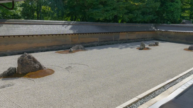
- Ryoanji Rock Garden: The Kyoto Temple Where Something Is Always Hidden
 You sit on the wooden veranda… 続きを読む: Ryoanji Rock Garden: The Kyoto Temple Where Something Is Always Hidden
 - Unzen Onsen 2026: Walking the Jigoku and a Bath That’s Been Running Since 1919
 Unzen sits on a volcano, at a… 続きを読む: Unzen Onsen 2026: Walking the Jigoku and a Bath That’s Been Running Since 1919
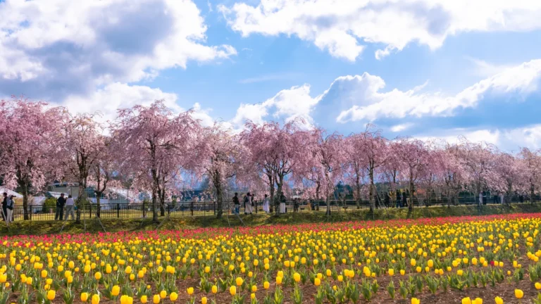
 - Hana no Miyako Koen 2026: Yamanakako’s Flower Park When the Sakura and Tulips Actually Overlap
 Hana no Miyako Koen (花の都公園) s… 続きを読む: Hana no Miyako Koen 2026: Yamanakako’s Flower Park When the Sakura and Tulips Actually Overlap
 - Hiruzen Highlands: Japan’s Alpine Middle, Jersey Cows, and a Weekend No One Talks About
 Hiruzen is one of those place… 続きを読む: Hiruzen Highlands: Japan’s Alpine Middle, Jersey Cows, and a Weekend No One Talks About
 - GREENable HIRUZEN: Kengo Kuma’s Traveling Pavilion Lands in Okayama’s Cow Country
 Drive forty minutes north of … 続きを読む: GREENable HIRUZEN: Kengo Kuma’s Traveling Pavilion Lands in Okayama’s Cow Country
2026 cherry blossom cherry blossoms day trip from tokyo flower festival fuji five lakes fujiyoshida Fukuoka fushimi hanami hiking japan japanese culture japanese food japanese garden japan travel kamakura kawagoe kawaguchiko Kumamoto kyoto local food Mount Fuji mt fuji Nagano nature Nikko Oku-Nikko Onsen Ramen saitama sakura Shizuoka shrine sightseeing snow spring spring in japan Tokyo travel travel guide travel planning winter winter travel Yamanashi
Join 1,000+ travelers discovering Japan's hidden side
Weekly dispatches from off-the-beaten-path Japan — spots and stories you won't find in guidebooks.
No spam. Unsubscribe anytime.
Welcome aboard!
You're in. See you in your inbox soon.