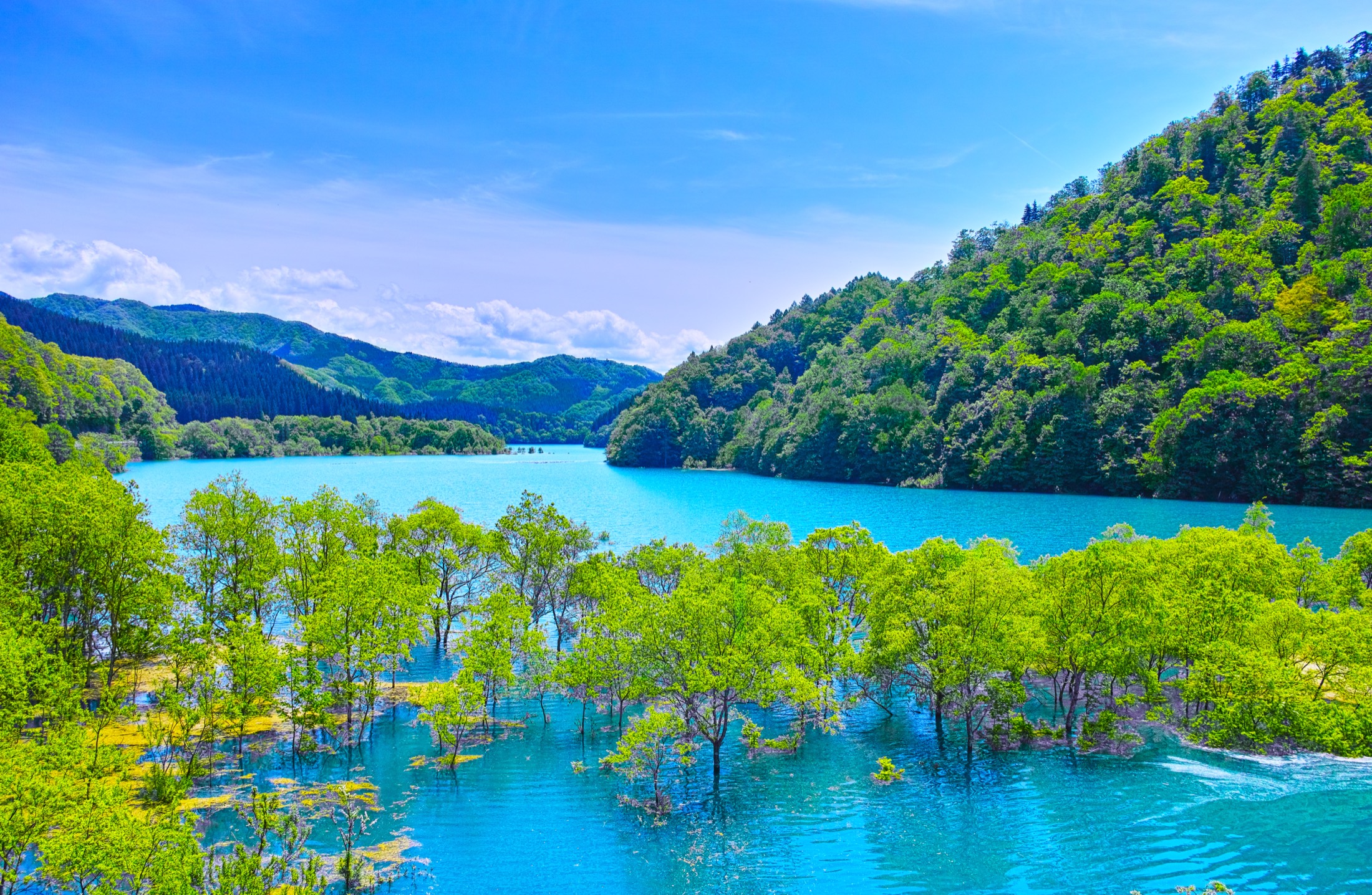
Akita · Semboku · Late Spring
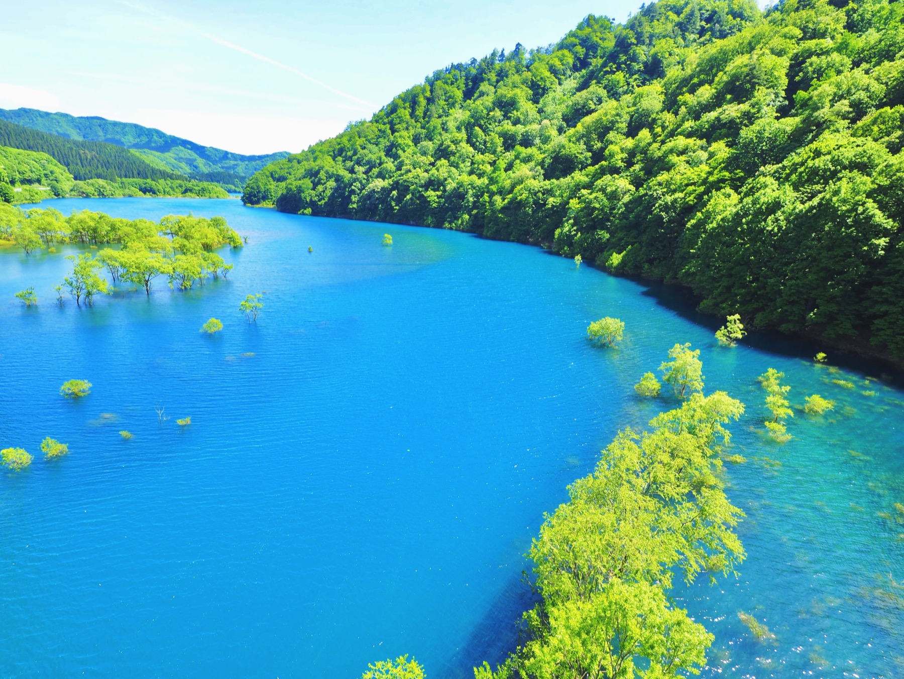
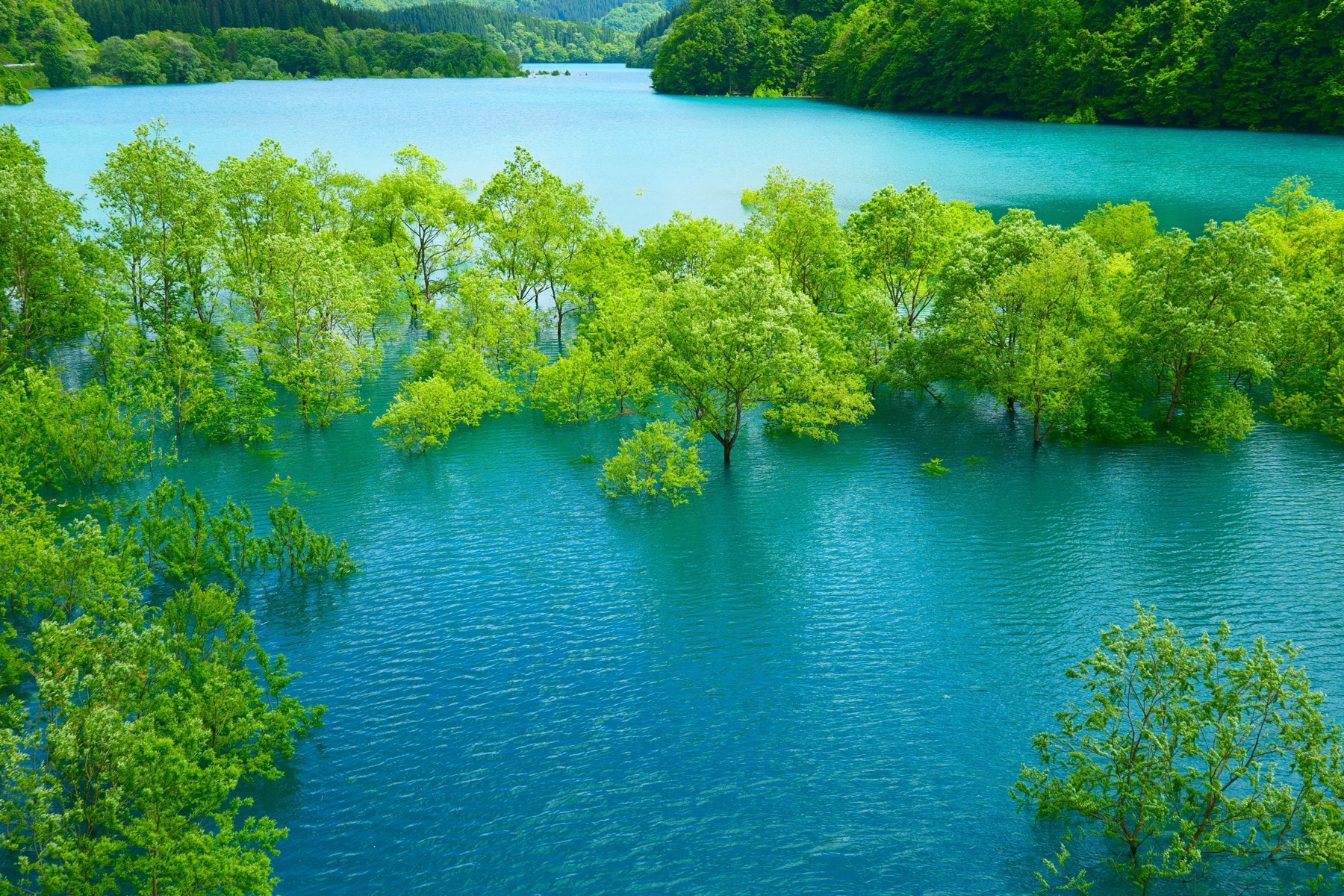
For about a month each spring, the trees along the shore of Lake Shusenko in Akita stand half-drowned in cobalt-blue water — a “submerged forest” that appears when snowmelt floods the 1957 Yoroibata dam reservoir, leafs the trees out at the waterline, and then drains away by mid-June. It’s one of Tohoku’s most photographed late-spring sights, usually at its best in early-to-mid May. And it may be on borrowed time: a planned power-station rebuild could close the view for years from around 2027.
What you’re actually looking at
Lake Shusenko (秋扇湖, Shūsenko) isn’t a natural lake. It’s the reservoir behind the Yoroibata Dam, a gravity-concrete dam finished in 1957 on the Tamagawa river — the first dam built on the Omono river system, for flood control and hydropower. The reservoir was named Shusenko by public vote in 1987.
The submerged forest is a side effect of how the dam is run. Through late April, snowmelt pours off the surrounding mountains and the reservoir rises until it swallows the trees growing along the banks — which then quietly leaf out with their trunks underwater. Then, from early-to-mid May, the dam starts releasing water downstream for the rice-planting season and to make room before the summer rains. As the level drops, the trees re-emerge. That month of rising-then-falling water is the whole show.
When to go
The window is short and a little unpredictable, because it depends entirely on the snowmelt and how fast the dam draws the water back down. As a rule it runs from early May to mid-June, lasts about a month, and looks its best in early-to-mid May, when the new leaves are bright and the water is highest. By mid-to-late June the level has usually dropped and the trees are back on dry ground. If you’re planning around it, treat early May as the safe bet and check recent photos before committing — a heavy or light snow year shifts the timing.
How to get there, and what’s nearby
Shusenko sits along National Route 341, near the Shin-Tamagawa Bridge, in the mountains north of Lake Tazawa. There’s no real public transport to the shore, so this is a drive: it’s about 20 minutes by car from JR Tazawako Station (reachable by Akita Shinkansen), or an easy detour if you’re already heading up Route 341 toward the hot springs. You view it from the roadside pull-offs and the bridge — bring a wide lens and go mid-morning to midday for the colour.
The lake pairs naturally with the rest of the Tazawako–Semboku corner of Akita: Lake Tazawa, Japan’s deepest lake, just south; Tamagawa Onsen, the powerful acidic spring further up Route 341 that gives Shusenko its colour; the cedar-and-hot-spring hamlets of Nyuto Onsen; and the samurai town of Kakunodate. It slots cleanly into a wider Tohoku itinerary.
Where to stay near Shusenko
The natural bases are around Lake Tazawa, Tamagawa Onsen or the Nyuto Onsen hamlets. Booking has the widest spread of Tazawako-area hotels; Rakuten Travel is stronger for the traditional onsen ryokan up in the hills, which are the reason to stay the night.
On the map
Good to know
What is the Lake Shusenko submerged forest?
It’s a stretch of shoreline trees that stand in the water each spring, when snowmelt raises the Yoroibata dam reservoir (Lake Shusenko) in Akita. The trees leaf out with their trunks underwater, set against unusually blue water, until the dam is drawn down and they return to dry land.
When can you see it in 2026?
Roughly early May to mid-June, lasting about a month, with the best colour usually in early-to-mid May. The exact timing shifts each year with the snowmelt and how quickly the dam releases water, so check recent photos before you travel.
Why is the water so blue?
The Tamagawa river upstream is highly acidic — it’s fed by Tamagawa Onsen — and is treated with lime to neutralise it. The dissolved minerals give the reservoir its milky cobalt-blue to emerald colour, which looks most vivid under direct sun.
How do I get to Lake Shusenko?
By car. It’s on National Route 341 near the Shin-Tamagawa Bridge, about 20 minutes’ drive from JR Tazawako Station (Akita Shinkansen). There’s no scheduled bus to the shore, so a rental car or taxi is needed; you view it from roadside pull-offs and the bridge.
Is it true the view might disappear?
Semboku City has noted that a rebuild of the Yoroibata power station is planned from around 2027 to 2032, during which the submerged forest may not be viewable. The current seasons are the reliable ones, so it’s worth seeing sooner rather than later.
What else is nearby?
Lake Tazawa (Japan’s deepest lake), Tamagawa Onsen, the Nyuto Onsen hot-spring hamlets, and the samurai town of Kakunodate are all in the same Semboku corner of Akita — enough for a two- or three-day loop, or part of a longer Tohoku trip.
Akita Kantō Festival
Akita’s other summer headline — ~280 lantern poles balanced on palms and foreheads, 3–6 August.
Tohoku 5-Day Itinerary
Build Shusenko into a wider northern trip — Sendai, Yamadera, Ginzan and more.
Japan in May
The shoulder month when the submerged forest is at its best, day by day.
Japan in June
Where the spring colour goes next — hydrangeas, fireflies and the rainy season.
Summer in Japan 2026
The whole warm season: weather, festivals and where to escape the heat.
Plan an Akita Trip
Three doors into the Tazawako corner of Akita. A car is the realistic way to reach the lake.
Join 1,000+ travelers discovering Japan's hidden side
Weekly dispatches from off-the-beaten-path Japan — spots and stories you won't find in guidebooks.
No spam. Unsubscribe anytime.
Welcome aboard!
You're in. See you in your inbox soon.