

Heart Rock (ハートロック) is a heart-shaped tide pool on the east coast of Amami Oshima, in Akagi village of Tatsugo Town (龍郷町赤尾木). It is fully submerged at high tide and only emerges when the water drops below roughly 80 cm, optimally near 50 cm — a window of about one to two hours, twice a day. The drive from Naze takes ~30 minutes; from Amami Airport ~15 minutes. Since May 2025, Tatsugo town has been warning that even at low tide the pool is frequently buried by wind-blown sand — check the town’s official Instagram before you drive over.
Tatsugo town’s official tourism page now carries a standing warning: since approximately May 2025, strong easterly winds have been pushing sand into the pool such that even at low tide the heart shape is often completely buried. The town posts current status (visible or buried) on its official Instagram account when conditions allow. Treat the rest of this guide as “what’s true when the pool is exposed” — and check the Instagram on the morning of your visit.
I drove to Heart Rock on the wrong tide once. Got out of the car, walked the ten minutes through the Adan trees, found about fifteen other people standing around staring at the sea, and realized I had been reading the high-tide column instead of the low-tide column on the tide table. The drive back to Naze was forty minutes long. I had budgeted ninety minutes for the entire stop. This is the kind of small navigation error that the Tatsugo town tourism office now puts on its public signage, because it happens often enough to be a pattern.
Where it actually is — and how to get there
Heart Rock sits on the east-facing reef of Bila Beach (ビラビーチ), in Akagi village (赤尾木), Tatsugo Town. Postal code 894-0411. The official navigation landmark most visitors use is the small café Soleil Farm (それいゆふぁ~む) on Prefectural Route 82, or the guesthouse Ufuta minshuku (民宿 宿うふた) a few hundred meters away — both at the same intersection. From either, there is a five-to-ten-minute walk down a sand path through Adan trees to the rocky reef where the pool sits.
| Address | 鹿児島県大島郡龍郷町赤尾木 (Akagi, Tatsugo Town) |
|---|---|
| From Amami Airport | ~13 min by car (~10 km). Bus option: Shima Bus 東海岸 line, ¥410. |
| From Naze city centre | ~30 min by car (~20 km). Bus ¥850+. |
| Parking | No official lot. Small courtesy lots near Soleil Farm / Ufuta. Fills in season. Walk: 5–10 min on a sand/forest path. |
| Admission | Free. |
| Toilets | None at the trail head. Last public toilet ~5 min back toward Tatsugo Town centre. |
| Town contact | 龍郷町役場 企画観光課 0997-69-4512 |
The tide window — what those numbers really mean
Heart Rock is a shallow depression in the coral reef shelf. At high tide it sits under 1.5 to 2 meters of seawater and is essentially invisible from shore. As the tide drops, the surrounding reef emerges first, leaving the pool isolated. The clean heart outline that everyone photographs only appears when the tide drops below about 80 cm. Below 50 cm the pool is fully exposed and you can stand on the surrounding rim. Above 1 m it is a vague shape under the water — not worth driving for.
Pool fully exposed, surrounding rim dry enough to stand on. Best for photos and the iconic “two of you on the heart edge” composition.
Heart shape visible but rim partially flooded. Wet feet inevitable. Still photogenic; reflection of sky in the pool is strongest in this range.
How to read the tide table (Naze JMA station, 2026)
Use the Japan Meteorological Agency’s Naze (名瀬) tide table as your authority — station code QJ. The Amami station (O9) further south works too but Naze is the closer reference point geographically. Both publish a 2026 PDF with daily highs and lows.
- Open the JMA Naze tide table at
data.jma.go.jp/kaiyou/db/tide/suisan/suisan.php?stn=QJ. The 2026 PDF lists every day of the year. - Find your visit date. Each day has two high tides and two low tides (“満潮” = high, “干潮” = low). Times are in JST.
- Look at the cm value beside 干潮. If either of the day’s two lows is below 80 cm, that low is your viewing slot. Plan to arrive about one hour before that timestamp.
- Cross-check with Tatsugo town’s Instagram the morning of, in case the pool is currently buried by sand drift. If it’s buried, no tide will help — the pool simply isn’t visible.
- If you have flexibility, prefer spring tide (大潮) days. These cluster around new and full moons, when the difference between high and low is largest and the lows are deepest. The JMA table marks 大潮 / 中潮 / 小潮 / 長潮 / 若潮 on each row.
Best months — two answers from two official sources
Tatsugo Town’s tourism page and the Amami Tourism Bureau both recommend January through March, because that’s when aosa sea lettuce blooms green in the pool, framing the heart shape in vivid color contrast against the turquoise water. The Amami Tours commercial guide recommends spring and autumn instead, because conditions on the reef are more stable and the lows fall during civilized daylight hours. Both are right for their criteria. The conflict is real, and the answer depends on what you’re optimizing for.
Best conditions (stable waves, daytime lows)
One nuance from the seasonal pattern: in spring and summer, the largest daily tidal drop tends to fall during daylight. In autumn and winter, the largest drop shifts to nighttime, when you can’t shoot the pool anyway. This is why November and December — though dry and pleasant on Amami otherwise — drop off the optimal list. The pool is exposed; it’s just exposed at 3 AM.
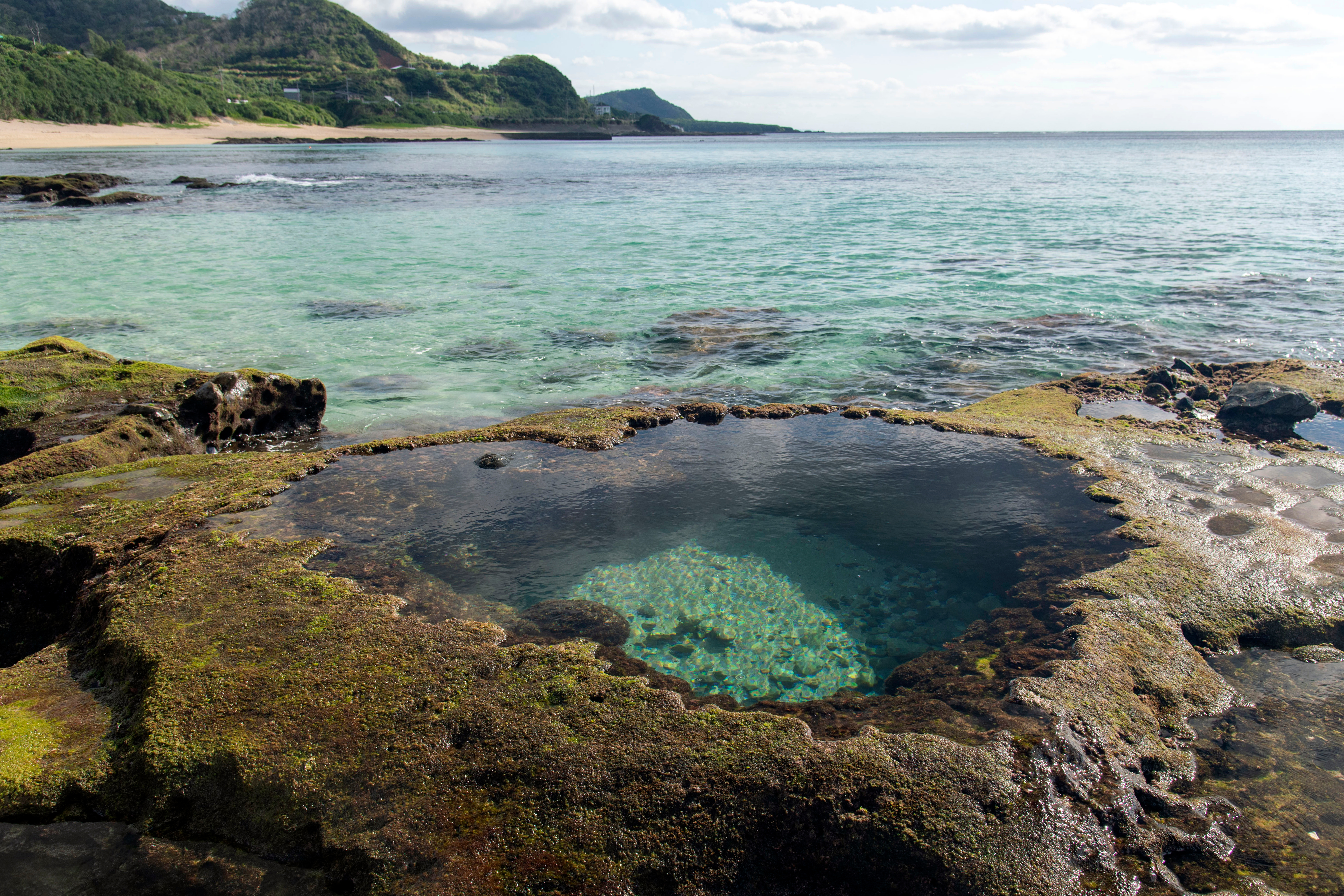
Heart Rock at about 60 cm tide — pool fully visible, rim partially flooded. The water inside is the same Pacific, but stilled by the rim. The dark patches under the surface are reef fish, not stones.
What you wear matters more than what you bring
The reef shelf is extraordinarily slippery. The Tatsugo town tourism page warns about this in every language version, and every guide I’ve read repeats it. Wet coral, biofilm, and tidepool algae give you a surface less grippy than wet ice. Closed-toe sneakers with deep tread are the minimum. Sandals are not adequate. Barefoot is reckless — the same coral that looks soft underwater cuts the soles of your feet open in two steps when you stand on a wet rim.
The forest path from the parking area runs through Adan trees and low subtropical brush. This is habu pit viper habitat — the venomous snake endemic to Amami and the surrounding islands. Daytime visits are generally safer than dawn or dusk; habu are most active in low light. Stay on the marked path. Habu bites on Amami are rare but they happen every year. The town hospital in Naze stocks antivenom.
High tide, regardless of how it looks. The reef rim is only a few centimeters above sea level even at moderate tide, and a single wave can sweep someone off into deeper water. Strong wind, even with low tide on paper. The pool is on the windward side of the island, and east swells stack. Typhoon-season weather (Jul–Oct, peak Aug–Sep). Outside daylight hours.
Photo composition — what the official guides actually say
Shoot from a slight low angle in front of the heart, not straight overhead. The classic overhead drone shot is not what the on-shore composition looks like; visitors who plan around the drone shot are disappointed when they arrive with only a phone. Morning and afternoon both work for light, but afternoon — when the sun comes from the southwest — produces shadow contour around the heart rim that makes the outline sharper. On a phone, enable HDR and underexpose slightly; the turquoise water tends to blow out the highlights otherwise.
If you want a person-in-frame composition for scale, position the figure at the edge of the rim and shoot from about three meters back. Wide-angle phone lenses exaggerate distance and make the heart look smaller than it reads in person — the pool is roughly 1.5 meters across at the widest point of the heart.
What else to do in the same area
Tatsugo Town is the entrance to the north coast of Amami; the drive from Heart Rock continues north along Route 82 toward Cape Ayamaru (あやまる岬) in about 30 minutes — a long grass headland with a panoramic ocean view and one of the better café-with-a-view stops on the island. South of Heart Rock by 40 minutes is Naze city with the Amami Park and the Hajime Tanaka Issoritsu Memorial Museum. The mangrove kayaks on the south coast (covered in a separate guide) take another 50 minutes south of Naze; combining Heart Rock and the mangroves in one day is feasible but tight on tide windows.
Plan This Trip
Flight
Kagoshima or Tokyo → Amami
JAL, Solaseed, and Skymark serve Amami Airport. 1 hour from Kagoshima, 2.5 hours from Haneda.
Drive
Rental car from Amami Airport
No public transport reaches Heart Rock practically. Rent at the airport on arrival.
Stay
Hotels in Naze
Most lodging clusters in Naze. 30 min from Heart Rock, 50 min from the mangroves.
Stay/Ryokan
Minshuku in Tatsugo
Smaller guesthouses 5–15 minutes from Heart Rock, including Ufuta near the trail head.
FAQ
How long does the actual visit take?
Is there really no parking lot or admission fee?
What if the pool is buried by sand?
Can I swim or snorkel in the pool?
Should I bring water and snacks to the trail head?
Sleep close to the timing window
If your tide window is at 06:30 or 19:00, staying in Naze means a 30-minute pre-dawn drive on a winding road. Booking a guesthouse in Tatsugo Town — Ufuta minshuku is one of several near the trail head — puts you 10 minutes from the pool and lets you walk down in slippers if you really want to.
Booking the Trip
Three doors into an Amami visit. Build the trip around the tide window, not the flight.
Stay
Hotels in Naze and Tatsugo
Naze for restaurant choice. Tatsugo if you’re optimising for sunrise tides.
Search on Booking →
Flight
Flights to Amami Airport
JAL from Kagoshima or Tokyo Haneda. Solaseed and Skymark also serve the route.
Find flights →
Drive
Rental car for the island
Pick up at Amami Airport. Heart Rock is 13 minutes south; the mangroves are an hour southwest.
Compare cars →
Related reading
- Kagoshima Outer Islands 2026: A Master Guide to Yakushima, Amami, Yoron and the Archipelago — the parent piece
- Amami Mangrove Kayak 2026: The High-Tide Half-Day on the Yakugachi River — pair Heart Rock with the mangroves for a full Amami day
- Tanegashima 2026: 1543 Muskets and a June 10 Rocket Launch — the other island in this Kagoshima cluster
Join 1,000+ travelers discovering Japan's hidden side
Weekly dispatches from off-the-beaten-path Japan — spots and stories you won't find in guidebooks.
No spam. Unsubscribe anytime.
Welcome aboard!
You're in. See you in your inbox soon.